|
|
Post by silva on Jun 10, 2023 9:03:55 GMT
 Praia do Canal, Costa Vicentina  Praia do Canal, Costa Vicentina. Praia da Amoreira flysch, Costa Vicentina. Praia da Amoreira: Beautiful white sand beach surrounded by flysch cliffs. The flysch rocks in the ground are more likely to be visible in spring and at low tide. Bring all your lenses for this spot, along with a good pair of waterproof boots! |
|
|
|
Post by silva on Jun 10, 2023 9:51:26 GMT
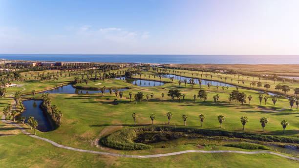
 Green golf courses by the sea. Salgados beach. Portugal,... Alfufeira |
|
|
|
Post by silva on Jun 13, 2023 11:17:22 GMT
Top 10 Cidades Mais Bonitas de Portugal - Top 10 Most Beautiful Cities in Portugal
The video has your language, you have to put it
A cidade de Lisboa é mais antiga do que a cidade de Roma - The city of Lisbon is older than the city of Rome
----------------
It is the second oldest European capital after Athens, and roughly four centuries older than Rome. Many historians believe it was settled by the Phoenicians around 1200 BC.
É a segunda capital europeia mais antiga depois de Atenas, e mais ou menos quatro séculos mais velha do que Roma. Muitos historiadores acreditam que foi estabelecida pelos fenícios perto de 1200 AC.
|
|
|
|
Post by silva on Jul 27, 2023 10:46:39 GMT
 Ria Formosa Natural Park Algarve  Ria Formosa  Praia da Cacela Velha This beach is separated from the mainland by a wide lagoon. Depending on the tide it requires a boat trip (from nearby Fábrica) or a long hike to get there. That also explains why the beach is usually mostly deserted. The water in the lagoon is shallow and a little warmer than the ocean. That makes the lagoon the ideal playground for the little ones. The charming whitewashed town of Cacela Velha is also worth a visit. If you want to spend a peaceful day at the beach and don’t mind the extra effort this is the place to go. It was named one of the best beaches of the world by Condé Nast Traveler in 2015.  Salt flats in the Ria Formosa seen from the Ludo trail |
|
|
|
Post by silva on Aug 2, 2023 9:36:28 GMT
|
|
|
|
Post by silva on Aug 2, 2023 10:06:43 GMT
|
|
|
|
Post by silva on Oct 31, 2023 21:29:27 GMT
Most Beautiful Places in Portugal 🇵🇹Video in Brazilian Portuguese. Choose your language in the video itself.
Lugares mais Bonitos de Portugal 🇵🇹 Video em português do Brasil.Escolha o seu idioma no próprio video.
|
|
|
|
Post by silva on Jan 7, 2024 18:58:59 GMT
PORTUGAL'S LANDSCAPE & REGIONS  The Regions of Portugal Portugal has a range of diverse landscapes for such a small country. It covers an area of 92,000 square kilometers roughly one-sixth of the total land mass of the Iberian Peninsula. Its varied geography, geology and landscapes range from the mountains of the Estrela to the dry plains of the Alentejo to its mostly low-lying coastline of 1,794 km and beaches. REGIONS OF PORTUGAL & THEIR LANDSCAPES The landscape of Portugal is roughly divisible into three main regions. These are the north, the interior of this northern region and the south. On the whole Portugal is a low-lying country with just over 12% of the country rising over 700 meters. The majority of these highlands are in the north with only the São Mamede range in the south over 1,000 meters in altitude.  The stunning landscape of Peneda-Gerês National Park (Parque Nacional Peneda-Gerês) THE NORTH The historic province of Minho in the far north west of Portugal, takes its name from the River Minho that forms the northern border with Spain. Minho lies west of Trás-os-Montes and is an area of outstanding natural beauty with mountains, river valleys and a dramatic Atlantic coastline (Costa Verde). The Larouco Mountains here reach a height of over 1,500 meters and are part of the Peneda-Gerês National Park (Parque Nacional Peneda-Gerês). Peneda-Gerês is the only National Park in Portugal. The Minho River is the fourth largest river in Iberia and the third longest in Portugal at 340 kilometres (210 miles). The river's source is north of the town of Lugo in Galicia. The river marks a stretch of the northern border dividing Spain and Portugal, best illustrated by the bridge spanning the towns of Tui and Valença. It reaches the Atlantic Ocean between A Guarda in Galicia and Caminha in Portugal. |
|
|
|
Post by silva on Jan 7, 2024 19:02:27 GMT
 The snowy mountains of the Serra da Estrela Natural Park NORTHERN INTERIOR In continental Portugal, the highest mountains are in the Serra da Estrela Natural Park. These mountains are the source of various important rivers - the Mondego, Zêzere (a tributary of the River Tagus), and the Alva. The park is also the largest natural conservation area in Portugal and covers approximately 1,000 km². Torre is the highest peak in continental Portugal and there is even a a ski resort - the Vodafone Ski Resort near to Covilhã - with snow in the winter months.  Óbidos Lagoon (Lagoa de Óbidos) is the largest in Portugal |
|
|
|
Post by silva on Jan 7, 2024 19:05:22 GMT
 Sofa with a view at Arrifana Beach, Aljezur, Algarve THE SOUTH South of the River Douro much of the country is at lower altitudes. The historic provinces of Beira Litoral and Estremadura are marked by marshy coasts and lagoons seen around the towns of Aveiro and Obidos to the south. Óbidos Lagoon (Lagoa de Óbidos) is the largest in Portugal and extends between the municipalities of Óbidos and Caldas da Rainha. Further south the Alto Alentejo is a continuation of the Spanish plateau with generally poor soils. The Baixo Alentejo, around the town of Beja, is known for its low, undulating landscape and its baking summer season. In Alentejo the landscape and climate much resembles Spanish Extremadura and Andalusia with limited rainfall. Further south is the Algarve which is more elevated. The Monchique Mountains reach over 900 meters at Mount Foia. The coastline of the south also tends to be high with steep cliffs on the western coast near Aljezur and on the southern coast around Lagos. The population density also increases near the coast in the Algarve where irrigation - used since Roman and Moorish times helps to improve  Cabo Girao on Madeira Island is the tallest cliff in western Europe MADEIRA The Madeira archipelago is made up of eight volcanic islands 1,000 km southwest of the Portuguese mainland. Only Madeira and Porto Santo are now inhabited. Porto Santo is low-lying, flat and dry whereas Madeira is mountainous, green and lush. Indeed, Porto Santo has little natural vegetation but does have in abundance the golden sandy beaches which Madeira lacks - a 9 km long stretch to be precise on the south of the island. On Madeira the interior mountains offer incredible sheer drops and spectacular waterfalls. These include the Cascata das Vinte e Cinco Fontes, the Risco Waterfall, the Cascata dos Anjos and Caldeirão Verde. Madeira's highest point, often shrouded in mist, is Pico Ruivo with an altitude of 1,861 meters (6,000ft). |
|
|
|
Post by silva on Jan 7, 2024 19:10:10 GMT
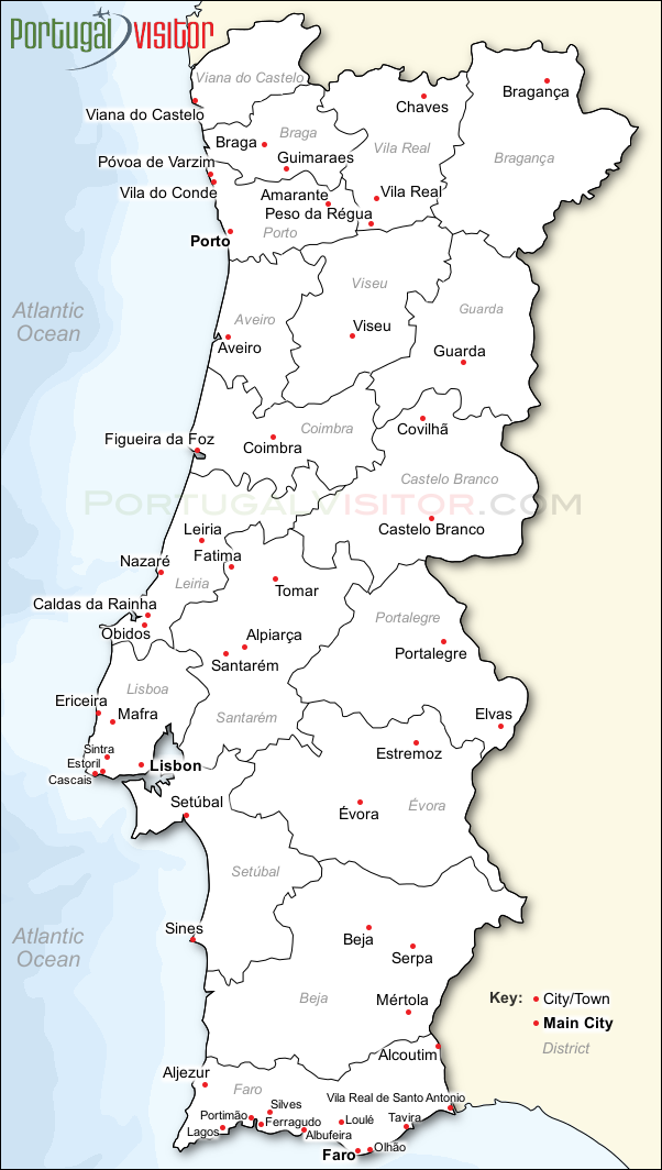
 Lagoa do Fogo (Lake/Lagoon of Fire), São Miguel, Azores, Portugal AZORES The Azores archipelago is made up of nine islands in three groups covering over 650 km in the mid-Atlantic. Santa Maria, the easternmost island is a distant 1,408 km from continental Portugal mainland with the westernmost island Flores, 1,899 km away almost the same distance to Newfoundland in Canada. The islands are volcanic and many are still active. The landscape here includes crater lakes, plateaus and rugged coastlines. Mount Pico on Pico Island is the highest point in Portugal rising to 2,351 meters.  Map of Portugal showing the main towns and cities |
|